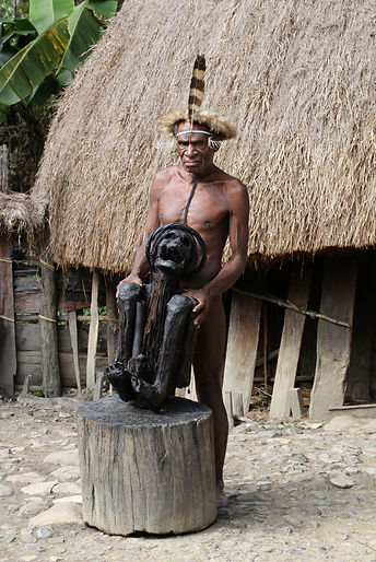
New Guinea


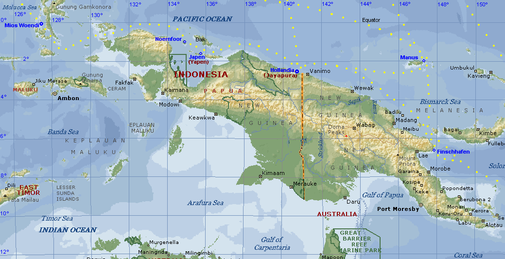
Formally Irian Jaya Now West Papua Indonesia is the western section of the world’s second largest island, New Guinea. The eastern half of this isle in Oceania is the Independent State of Papua New Guinea otherwise referred to as Papua New Guinea or PNG (national geographic 2004).
As does West Papua, Papua New Guinea consists of a mainland and a collection of islands. Along the 141º east longitude a political boundary bisects the rocky topography of this tropical island effectively into two regions. Extending mid-line in an east-west direction for more than 2,500 km (1,555 miles) is the central cordillera, composed of a vast mountain range. The mountains within this formation are geologically young and consist of sedimentary limestone, sandstone, and shale that have been uplifted and faulted on a massive scale by plate movements. The central cordillera traces the precise line where the Sahul Shelf and the Pacific Ocean Plate meet those of the ancient continent of Australia and of the Pacific Ocean.
(Muller 1997)
The topography of West papua a is divided into three parts, the Bird’s Head area (also well known by its previous name, Vogelkop Peninsula, so named by the Dutch colonists), the area between the central mountains and the northern beaches, and the area south of the Jayawijaya Highlands
The tropical highland of this Eco-region spanning West Papua and Papua New Guinea is incongruously decked with a small number of permanent snowfields and glaciers within the Alpine zone of the Central Mountain Range (Asian Pacific Mountain Network 2005). Southwest of the Baliem Valley within the Jayawijaya Range, Gunung Trikora soars to 4,743 meters. Westward from the Papua New Guinea border is Wusnumurti’s Gunung Mandala, an imposing peak at 4,700 meters above sea level. Numerous mountains within the Alpine Range crest 4,000 meters, nevertheless the highest point between the Himalayas and the Andes lies within the Sudirman Range, southwest of the Paniai Lakes. At 4,595 meters above sea level Pancak Jayakésuma (Pancak Jaya) is the crowning peak of Irian Jaya.
These three continuous mountain ranges, Wisnumurti, Jayawijaya and Sudirmanare, are distinguished by a number of significant geographical features and treasures. The Sudirman Range is home to one of the five largest copper mines in the world and the single largest gold reserve of any mine in the world. (Muller 1997) Where the northern slopes of the central cordillera progressively descend, foothills are seen pointing the way to the Mamberamo basin. Much of this flat and marshy area sheltered by lowland forests within the Lake Plains region has not
been extensively explored. Yet within this terrain two tributaries, the
Taritatu and Tariku, flowing from the east and west, respectively, branch
off to create thousands of waterways and the crescent-shaped lakes that
lay alongside the winding rivers. The south-facing slopes of the central
cordillera plunge abruptly. The ecosystem below the slopes is abundant
with forest vegetation. Nevertheless this terrain gradually secedes meeting
a coastal swamp, which in some places reaches 300 kilometers inland. Even
so the far southeastern corner of Irian Jaya is a large atypical stretch of dry
grassy Savannah (Muller 1997). Possibly the most dense mangrove marsh
in the world can be found along the edge of the Bintuni Bay while the area
north of the bay is rich in lowland forests. The Tamrau and Arfak mountains
appear north of the southern region of the Bird’s Head area. The Rja Empat
islands, Waigeo, Batanta and Salawati, are islands near Sorong. The island
of Misool is found in the Bay of the Bird of Paradise.
Dramatic geographical diversity marks the nineteen provinces of PNG.
Within the East Sepik Province dense rainforests cover the north coast
as well as mountains north and south of the river basin. The Sepik River
may be compared to the Amazon and Congo Rivers in its power, and
magnitude. On the southern coast four rivers within the Gulf Province, the
Turama, Kikori, Purari and Vailala follow a course into the marshy delta land
of the Papuan Gulf. Vulcan, an active volcano in the East New Britain Province
continues to send clouds of black ash-filled smoke into
the tropical sky while to all intents and purposes. Much of the West New Britain Province is unaltered, uncharted and in a sense, mysterious. The Enga and Western Provinces share a rugged mountain border. Mandang Province is famous for its
unparalleled coral reefs and clearwater. The Admiralty Islands are an assemblage of islands and uninhabited atolls that converge on the equator with its northern border. The second largest gold deposit is located on Lihir Island within the New Ireland province. Glaciers in Irian Jaya and warm water fjords on the southeastern coast of PNG’s Oro Province are unexpected anomalies. The Sandaun Province is covered in rainforest. Simbu Province is marked by a rugged landscape, accounting for many inaccessible areas within this smallest of provinces in PNG. The highest peak in Papua New Guinea is found here. The two main islands of the North Solomons Province are located northeast of mainland Papua New Guinea. Caves of unparalled profundity have been the source of significant finds in the Southern Highlands. Bordering Irian Jaya on the southern coast is the Western Province where one of the largest gold and copper mines in the world has been in operation since 1980. The Western Province includes countryside with wide, open grasslands unique to PNG. Two of the greatest rivers in the country, the Fly and Strickland, are notorious for delivering almost five times the essential amount of water to the province during the wet season.
The Huon Peninsula, situated within the Morobe Province, is home to the Saruwaged Mountains. Located at the tip of the peninsula the area is considered by many to be an impenetrable rain forest. Within the peninsula, the lush Markham Valley is flanked by imposing mountains. Volcanic islands dot the ocean between the peninsula and New Britain. Serving as a major port and connecting highway to all other provinces in PNG and Irian Jaya, Lae became the second largest city in New Guinea during the 1920’s gold rush. Lae is also an influential city in regard to the study and preservation of the region’s endangered and threatened species. The Rain forest Habitat at Lae is a recreation of the natural rain forest of the region. The 3,000 square meter habitat is home to 15,000 native and exotic plants and animals found in Papua New Guinea. The Roger Williams Park Zoo in Providence Rhode Island has promoted a worldwide campaign to develop an additional 50,000 acre rain forest conservation area to serve as a safe haven for thousands of animals.
The central highlands and tropical mountain rain forests of Papua New Guinea and Irian Jaya were, until recently, as unspoiled and geographically diverse as they had been for many thousands of years. An unimaginable variety of ecosystems stretch its length and breadth (jungles, alpine mountains, semi-evergreen rain forests, temperate dry forests, tropical moist deciduous forests, tropical mountainous evergreen forests, lowland semi-evergreen and upper mountain forests), yet the country now faces exploitation of world marketable products while the number of areas experiencing ongoing commercial deforestation increase as a consequence of the protection of only 20% of the land in the form of national parks.


All images are Copyright by Ari R Flagle 2025